


Wheeling Twp. Voting District, Rice County, Minnesota
About
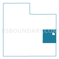
Outline

Summary
| Unique Area Identifier | 604078 |
| Name | Wheeling Twp. Voting District |
| County | Rice County |
| State | Minnesota |
| Area (square miles) | 34.56 |
| Land Area (square miles) | 34.56 |
| Water Area (square miles) | 0.00 |
| % of Land Area | 100.00 |
| % of Water Area | 0.00 |
| Latitude of the Internal Point | 44.32643640 |
| Longtitude of the Internal Point | -93.10241450 |
Maps

Graphs
Select a template below for downloading or customizing gragh for Wheeling Twp. Voting District, Rice County, Minnesota


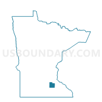
Neighbors
Neighoring Voting District (by Name) Neighboring Voting District on the Map
- Bridgewater Twp. Voting District, Rice County, MN
- Cannon City Twp. Voting District, Rice County, MN
- Holden Twp. Voting District, Goodhue County, MN
- Kenyon Twp. Voting District, Goodhue County, MN
- Nerstrand Voting District, Rice County, MN
- Northfield Twp. Voting District, Rice County, MN
- Richland Twp. Voting District, Rice County, MN
- Walcott Twp. Voting District, Rice County, MN
- Warsaw Twp. Voting District, Goodhue County, MN
Top 10 Neighboring County Subdivision (by Population) Neighboring County Subdivision on the Map
- Bridgewater township, Rice County, MN (1,772)
- Cannon City township, Rice County, MN (1,215)
- Walcott township, Rice County, MN (953)
- Northfield township, Rice County, MN (842)
- Warsaw township, Goodhue County, MN (607)
- Wheeling township, Rice County, MN (551)
- Holden township, Goodhue County, MN (454)
- Richland township, Rice County, MN (416)
- Kenyon township, Goodhue County, MN (393)
- Nerstrand city, Rice County, MN (295)
Top 10 Neighboring Place (by Population) Neighboring Place on the Map
Top 10 Neighboring Unified School District (by Population) Neighboring Unified School District on the Map
- Faribault Public School District, MN (30,624)
- Northfield Public School District, MN (27,800)
- Kenyon-Wanamingo School District, MN (5,509)
Top 10 Neighboring State Legislative District Lower Chamber (by Population) Neighboring State Legislative District Lower Chamber on the Map
- State House District 36B, MN (50,199)
- State House District 25B, MN (45,574)
- State House District 26B, MN (38,912)
- State House District 28B, MN (37,991)
Top 10 Neighboring State Legislative District Upper Chamber (by Population) Neighboring State Legislative District Upper Chamber on the Map
- State Senate District 36, MN (96,657)
- State Senate District 25, MN (85,965)
- State Senate District 26, MN (78,377)
- State Senate District 28, MN (75,659)
Top 10 Neighboring 111th Congressional District (by Population) Neighboring 111th Congressional District on the Map
Top 10 Neighboring Census Tract (by Population) Neighboring Census Tract on the Map
- Census Tract 702, Rice County, MN (5,314)
- Census Tract 704, Rice County, MN (4,448)
- Census Tract 805, Goodhue County, MN (3,495)
- Census Tract 807, Goodhue County, MN (3,490)